
The chart shows the Slocan Lake level for 2019 comparing it to an average of the previous four years.
This chart and all of the data gathering are courtesy of Hennig von Krogh.

Slocan Lake Christmas Bird Count Summary
The annual Slocan Lake Christmas Bird Count took place on December 28, 2019. The day was nice with broken cloud, no wind and just under freezing. A special ‘Thank You’ goes out to the twenty-three people who participated in this year’s count in the Slocan Lake Circle and the six who counted down the valley at Passmore, Vallican and Perry’s bridge area. The “Slocan Lake Circle” is defined as a circle centered approximately at the golf course and runs from Hills to lower Red Mountain Road.
Twenty-six species were observed on the count day with 5 more recorded during the 3 days before and after the 28th count day (Christmas Week). This is about the same number of species that we have been getting in the past three years.
This year we saw 307 birds. The results are submitted to Bird Studies Canada and the National Audubon Society. The latter maintains the massive database of Christmas Bird Counts going back to 1900, the year of the first count.
The following species and numbers were observed: Canada Goose(16), Trumpeter Swan(1), Mallard (2), Ruffed Grouse(2), Wild Turkey(4), Horned Grebe(1), Downy Woodpecker(3), Northern Flicker(10), Steller’s Jay(35), American Crow(20), Raven(5), Black-capped Chickadee(42), Mountain Chickadee(5), Chestnut-backed Chickadee(12), Red-breasted Nuthatch(17), Pacific Wren(1), American Dipper(9), Golden-crowned Kinglet(5), Varied Thrush(1), Song Sparrow(10), Dark-eyed Junco(1), Pine Siskin(79), Evening Grosbeak(16), Pine Grosbeak(7), and House Sparrow(2). During Christmas Week we added Great Horned Owl(1), Common Merganser(4),Hairy Woodpecker(1), Pileated Woodpecker(1), and Brown Creeper(1).
The birds that volunteers count down the valley are always interesting and records are kept of these numbers for future reference when we are able to get “circles” established in the southern valley. They saw birds that we did not see here like Swans(114), Buffleheads(8), Common Mergansers(10), American Goldfinch(20). They recorded 23 species and 253 birds.
If you would like to join in the fun and count birds that are here during the Christmas season, please send me an email: richard.slrc@gmail.com
Richard Johnson
Cumulative Effects Framework, Silverton Creek BC
A report on the cumulative effects of human (e.g. roads, timber harvesting) and natural forces (e.g. wildfires) on the Silverton Creek watershed has been prepared and is available here for download. The mapping and report use the benchmarks and protocol listed in the BC Government’s “Interim Assessment Protocol for Aquatic Ecosystems in British Columbia”, January 2017
Because of the size of the report it is broken into two parts, the main report and the maps which, when put into Appendix A make up the full report. The main report shows the map portion of the pdf map at smaller size so that the reader can work with the whole report without downloading the Appendix A maps. The main report can be downloaded by clicking CumulativeEffectsFramework-SilvertonBC_Report
The maps are available to download by clicking on the individual maps listed below.
Please contact Richard Johnson at richard.slrc@gmail.com if you have any problems
QGIS Course May 3, 2019
Once again the Columbia Mountain Institute is hosting the Introduction to QGIS course. This course was held in Revelstoke in 2017 and in Cranbrook in the spring of 2018. This year the course will be again be held in Revelstoke on May 3, 2019. It will be announced on the CMI website (http://cmiae.org/) shortly.
The course shows participants how easy it is to use the QGIS program by having them import data, analyze data and produce maps. The following is an excerpt from their website:
The free, open source QGIS program is used and supported by a world-wide array of developers. Learn how to use this program to produce maps from public databases and your own knowledge. In a hands-on environment, on their own computers, students will create basic maps, add lines, shapes, overlay images, create contours, add labels and produce high quality maps for print or digital presentation.
The course can also be taken on-line, direct from Opus Petroleum Engineering Ltd. Contact us at http://www.opuspetroleum.com/index.html for more information.
Richard Johnson, Opus Petroleum Engineering Ltd.
QGIS Workshops
An “Introduction to QGIS” workshop was put on by the Columbia Mountain Institute at Revelstoke on November 19th, 2017. The course was lead by Richard Johnson, president of Opus Petroleum Engineering Ltd. and founder of the Slocan Lake Research Centre. Fifteen people attended. All the feedback was very positive and we plan on putting it on again in the spring.
For the use of those that attended, we have created a pdf version of the course PowerPoint presentations. They are in greyscale but can refresh your mind. All of the attendees have Richard’s email and he will forward any of them to you at your request. Because of the size of the files you might want to get only some of them. They are titled “DEM”, “Vectors”, “Composer”, “GPS” and “Satellite” which is the order in which they were presented.
And of course Richard welcomes your continued questions and comments, on this page or by email.
Bird Recording Project
SWAMP has recently acquired a Song Meter SM4 for recording bird songs and calls in the various wetlands in the Slocan Valley. These recorders are completely programmable as to when, how often and how long they record so they are ideal for archiving what birds were in the area where the recorder was deployed. This is the start of a project to document the bird use of our wetlands. We will have a permanent record of any changes in bird migration and breeding over time.
 Testing of the unit in this area has resulted in the capture of the call of a Northern Saw-whet Owl just outside of New Denver. He called for several late evenings for a couple of hours each night and moves around while calling but monotonously repeats his beeping, like a persistently backing-up garbage truck. The photo is from Cornell Lab of Ornithology website.

The attached picture shows one minute of his calling via a sonogram. The horizontal axis is time, the vertical, frequency. The little yellow bars are the calls. To hear the actual calls please email me for a download or visit the MacCauley Library at Cornell Lab of Ornithology. Link: https://search.macaulaylibrary.org/catalog?q=Northern+Saw-whet+Owl+-+Aegolius+acadicus&searchField=species&taxonCode=nswowl®ionCode=&userId=
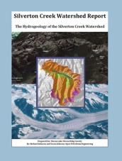
Completed Hydrogeology Studies
In 2016 the Slocan Lake Stewardship Society received a grant from the Columbia Basin Trust under their CIP-AAP program to perform two studies of the hydrogeology of the Silverton Creek area.
The first study examines the Silverton Aquifer, the alluvial delta upon which the Village of Silverton has been built. It relates the water in the aquifer, from which the Village gets its drinking water, to Silverton Creek and its watershed.
The second study relates the Silverton Creek watershed to the bedrock and glacial geology that have controlled its development. It then goes on the describe how this relates to the water flow and water quality.
Both reports can be download by clicking the images below.

Slocan Lake Water Level
This chart shows the lake level history since December 2014 together with the mean temperature and precipitation. These weekly measurements are being taken by Hennig von Krogh in New Denver. We will periodically update the graph and publish it on this website.

Western Toad Migration at Summit Lake getting ready to start.
The annual Western Toad migration from Summit Lake to their winter range up the mountainside to the south has begun with the toads staging at the lakeshore. The following is from Bruce Cottingham who was at Summit Lake yesterday, August 6, 2014.
It appears that the toadlets are starting to gather in relatively limited numbers at the moment. However, apparently there are large numbers in the lake on their way to the beaches. Biggest gathering noticed was at the Day Park boat launch as per picture attached.

Western Toads staging for the migration.
The annual Summit Lake Toadfest, sponsored by the Fish and Wildlife Compensation Program, is scheduled for August 26 and 27, 2014 but the toads have their own calendar. Angus Glass, coordinator of Toadfest, reports that this is earlier than usual and “… And yes, given the hot dry weather may be best not to move any right now, especially as they do like to hang out in the staging areas, possibly for a week or more. They will be looking for rainfall for sure.”
Let’s hope for rain when the toads are ready.
Western Toads and Spring Beauties
On May 16, 2014 I took a trip to Fish Lake Lake (50 deg 03 min 40 sec N, 117 deg 10’ 51 sec W, elev. 1074 m.). At the picnic site at the east end of the lake I was happy to see about 20 Western Toads by standing in one spot and watching along just 30 meters of shoreline. Two were already coupled, so the spawning season has begun. I took several pictures.

Nearby I took some pictures of a large patch of white Claytonia sp.in full bloom. Verena Shaw had pointed out to me on a previous trip. My books calls them Spring Beauties but I have also heard them called Snowdrops. They were growing on an outwash fan and mingled with them were yellow Glacier Lilies (Erythronium grandiflorum) and yellow violets (prob. Viola orbiculata). All excellent Grizzly bear food I understand.


